deserts: Location & climate
Desert environments form as a result of very low rainfall. Deserts can be defined as a region which receives less than 250mm of precipitation per year. As a result deserts have a unique landscape and flora and fauna have had to adapt to live there.
|
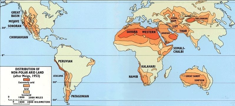
Climate graph for Kuwait
|
|
|
|

Research activity
|
The graph above shows that plants and animals in the desert have to cope with very little rain. There is also a big variation between day and night.
|
causes of deserts
|
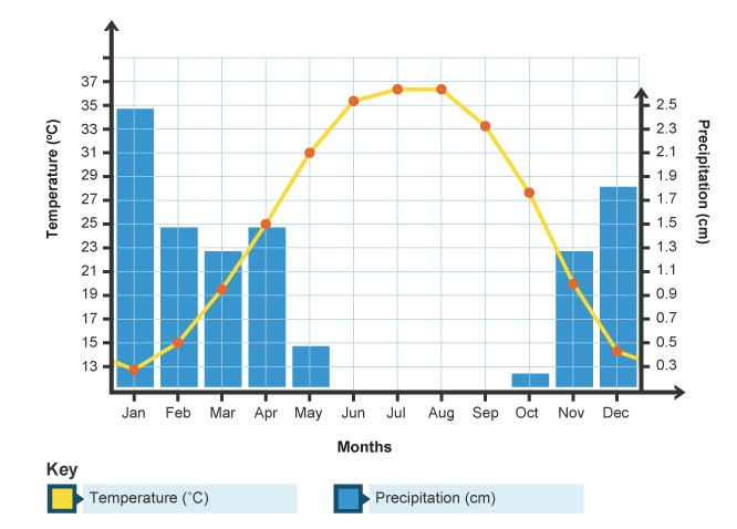
1. High Pressure
Air around the Tropics of Capricorn and Cancer is dry. This is a zone of high air pressure where the air sinks. Air at the equator rises and cools - condensation then forms rain. The air then moves north and south until it gets to about 30° north and south of the equator, where it sinks. This air is dry and no condensation can form, so there is no rain. This is known as the Hadley Cell. It shows how air moves around the atmosphere near the equator and tropics. |
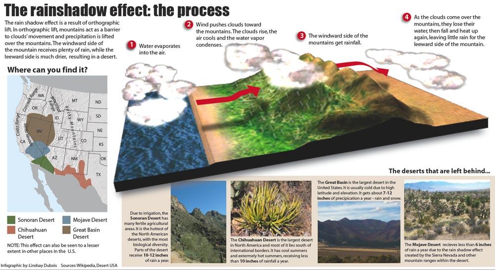
2. The Rain Shadow effect
3. Cold Ocean Currents
Some deserts are found on the western edges of continents. They are caused by cold ocean currents, which run along the coast. They cool the air and make it harder for the air to hold moisture. Most moisture falls as rain before it reaches the land, eg the Namib Desert in Africa.
4. Continentality
Continental deserts like the Gobi in China and Mongolia form as a result of their location in continental interiors. Most rain-carrying currents come from the sea, picking up moisture along the way. The air moves over the land it gets drier and drier inland and therefore creates deserts or arid environments. These deserts are called continental deserts because of their location inland. They have the most fluctuating temperatures in the world. For example example: in Gobi, the temperatures range varies between 45ºC in summer and -40ºC in winter.
Continental deserts like the Gobi in China and Mongolia form as a result of their location in continental interiors. Most rain-carrying currents come from the sea, picking up moisture along the way. The air moves over the land it gets drier and drier inland and therefore creates deserts or arid environments. These deserts are called continental deserts because of their location inland. They have the most fluctuating temperatures in the world. For example example: in Gobi, the temperatures range varies between 45ºC in summer and -40ºC in winter.
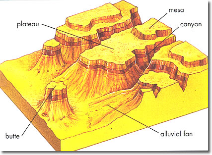
Desert landforms
|
|
Deposition and Dunes
Wind deposition is similar to that of water. Wind shifts from transport to deposition when the energy (velocity) of the wind drops below that which can sustain the sediment load it is carrying. The sediment load is either suspended in the wind current as a suspended load or rolls and bounces along the ground as the saltation load. The most common depositional landform that the wind leaves behind is the dune. typically dunes have a low slope face, called the windward face, that faces the wind direction and a steeper face, called the slip face, which points downward. Dunes move by the wind eroding sand from the windward face by pushing and bouncing along the windward face until it reaches the top of the dune. |
Deserts also create very distinctive landforms. Rates of erosion are speed up because of intense variations in heat between day and night. Also the movement of the sand suspended in the wind erodes the landscape.
|
|
|

|
Desert Landforms activity
|
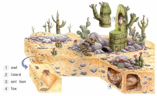
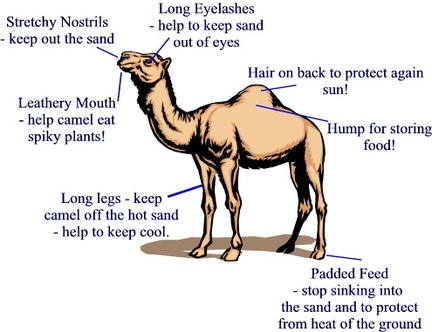
adaptations
Desert ecosystems are especially adapted to the hot and dry climate. Naturally there is less vegetation that can survive in the dry conditions but it is wrong to imagine deserts as lifeless and desolate environments. As the image below on the left shows many animals can adapt to take shelter from the sun.
|
|
|
|
|
|
|
|
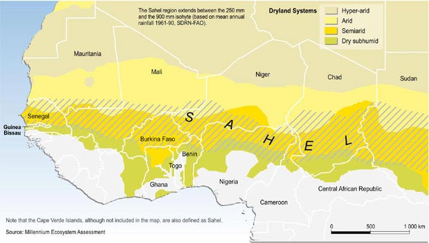
semi arid environments & desertification
Semi-arid regions are dry regions with very little annual rainfall, only up 700mm per year. They are also densely populated and this places enormous strain on the natural resources. People in these regions are mainly subsistent farmers or nomadic herders. With increased population pressure and the effects of climate change, such as increased droughts, these parts of the world are at risk of desertification.
Desertification refers to the degradation of semi-arid regions. It is caused by a combination of physical and human factors. Population growth leads to increased pressure on the land from farming and cattle. there is also more need for wood for firewood. in addition climate change is reducing the frequency of rainfall events. All of these factors lead to soil erosion.
Desertification refers to the degradation of semi-arid regions. It is caused by a combination of physical and human factors. Population growth leads to increased pressure on the land from farming and cattle. there is also more need for wood for firewood. in addition climate change is reducing the frequency of rainfall events. All of these factors lead to soil erosion.
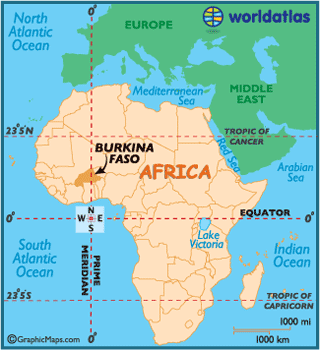
Living sustainably in burkina faso |
Burkina Faso lies largely in the Sahel region - a belt of semi-arid land that borders the Sahara desert. During the hottest months from March to May, temperatures rise to over 40°C during the day. Burkina Faso has a low rainfall and the rainy season runs from June to October.
|
|
Burkina Faso is one of the 10 poorest countries in the world. It has a population of 16 million, 1 million of which live in the capital, Ouagadougou. Most of the population depends on farming for their livelihood. Most farmers use hand tools and rely on rainfall to water their crops. Thus they suffer from many problems as the Sahel is a fragile environment where the rainfall is sparse and unreliable. The dry conditions of the Sahara desert have been creeping south, turning productive farmland into desert. One of the main reasons behidn this change is deforestation - the farmers clear land for crops and remove trees for fuelwood.
|
|
|

Dragons' Den Competition
|

Possible projects
|
